Petit-Saut sawmill: 31 monthly visits, three time-lapses and a corporate film
The Petit-Saut lake formed from 1994 behind the dam built on the Sinnamary river. The drowned forest is still standing: its dead trunks rise out of the water. Triton, a Voltalia subsidiary, harvests this timber and processes it in a sawmill built on the shore, next to Voltalia’s biomass plant, which turns species unsuitable for sawing into electricity. We have worked for Triton since 2018 and photographed the construction of its sawmill every month from March 2023 to September 2025.
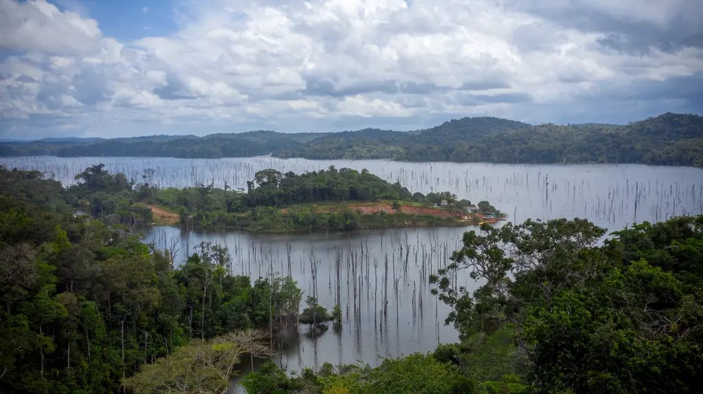
2018: 2,700 photos of the lake, taken from a boat
In 2018 Triton was preparing its project and wanted georeferenced aerial photos of six areas of the lake, 1,865 ha in total, to produce its own orthophotos. A trial over about a hundred hectares, at 15 and 20 cm per pixel, was flown on 28 April with the agreement of the dam management. The campaign started in early July with a high lake and unsettled weather: three days were lost to rain and an aircraft-mounted set-up was tried without success. The flights were finally carried out from a boat, with a boatman, until early August. On 9 August we delivered 2,700 georeferenced photos at 15 cm per pixel, 27 GB of data.
2020: looking for giant otter dens
In late 2019, once the project permits had been granted, a naturalist association suggested checking by drone for giant otter dens on the islands near the landing. On 12 January 2020 a first flight with a 4K wide-angle camera covered part of the shores of the smallest island, completed by a walk around it; on the 14th a second flight with a 30x zoom camera went over the shores more closely. The videos were delivered with their GPS subtitles and a report of the flight paths. No den was found; the client considered the trial conclusive.
2023–2025: one visit a month
Monitoring of the works was ordered in January 2023, together with a baseline for the project’s visual impact assessment. In February eight viewpoints, seven on the ground and one aerial, were photographed so that they could be repeated identically in the following years, and an orthophoto of the site was produced. The first monthly visit took place on 6 March 2023, the thirty-first on 23 September 2025. On each visit the northern and southern platforms were photographed in JPEG and RAW, and the images were filed by date in a folder shared with the operator.
Three site cameras complemented these visits. The first ran from April to June 2023, the second on the southern platform from 2 April to August 2024, with one- and two-minute edits. The third, installed in the sawmill on 1 July 2025 for three months, was extended at the operator’s request until 18 November; the final edit, with its logo and the months shown on screen, was delivered in December 2025.
An archive put to use
For the inauguration of the sawmill and energy hub on 14 October 2025, the event video was edited from the construction photos and time-lapses, and the nine albums of the inauguration virtual tour were drawn from them. In 2026 we shot the footage for a corporate film over several visits between January and August: the end of the timber route, sawmill output, species, uses. A 40-second short version was delivered in September and the full film on 14 October 2026. The virtual tour of the sawmill and the lake was rebuilt at the same time: 35 panoramas, five videos and ten albums in the May version, 360° videos in the August one. The operator is also considering using it for the safety induction of new arrivals.
Platform stockpile volumes
On 21 July 2026 we surveyed the northern and southern platforms to calculate the stockpiles. The orthophoto and the 3D model were shared online: the operator drew the outline of each stockpile itself, some of them resting on 30 cm blocks, then we calculated the volumes on the digital elevation model and delivered three plans, for the northern, central and southern areas. A trial analysis of the lake’s submerged trees, on a 3 ha test plot, is scheduled for late October.